I don’t know a lot about this area of BC, nevermind the Indigenous communities that live here. It sounds like hard times in this area – low employment and the Indigenous communities in this area want the pipeline to go through. There are a lot of boom and bust resource based economies. The pipeline and Site C dam would create a lot of employment and bring it much needed money and services to this region.
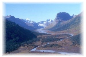
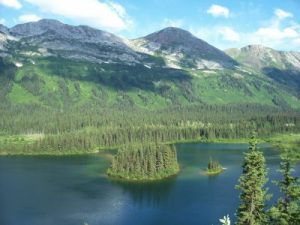
The region is very remote but with beautiful wildlife and nature. It is also interesting how colonialism came later to this region than the south of BC. I am interested to know what the implications of this would be, but I could not find information on this.
First Nations Population: 4,712
Total Population: 65,700
Population % First Nations: 7.17%
The Northeast region encompasses 202,502 square kilometres of land, making up approximately 22% of B.C.’s total land base.
It is separated from the northwestern part of the province by the Rocky Mountain Trench. The main population and commercial centres in the region are Fort St. John and Dawson Creek.
With much of the region lying east of the Rockies, the physical geography of the Northeast is distinct from much of the rest of the province: a vast and remote area of foothills, forests, lakes and the Peace River valley.
The traditional economy of the Dene Tha’ and Acho Dene Koe cultural groups was based on a semi-nomadic hunting and gathering society. The less mountainous nature of the terrain east of the Rockies facilitated relatively easy and efficient movement throughout the territory. Being so far north, the colonial economic influence on the region began later than in the south of the province. In the early twentieth century, numerous regional First Nations signed onto Treaty 8 (drafted originally in 1899), which secured access to and protection of the lands upon the traditional economy was built.
The twentieth century brought colonial settlements and growth logging industry took over from the early colonial fur trade as the dominant economic driver. With European settlement also came cattle ranching and dairy production. Recent years have seen rapid growth of the energy sector and increased employment in the region, with an increased number of non-residents moving to the region to join the labour force. However, as is often the case in remote resource-based economies, great challenges exist in mitigating the boom-bust cycles of resource extraction, and relatedly, ensuring that developments do not impinge on the rights and quality of life of First Nations and local stakeholders who must live with the consequences of development in immediate proximity.
There are many power-generating projects in the planning stages; these include the proposed $7.9 billion B.C. Hydro Site C project. The Site C dam is poised to contribute to economic growth in the region, but opponents worry about the significant flooding of Peace River Valley it would entail, among other concerns.
There are many power-generating projects in the planning stages; these include the proposed $7.9 billion B.C. Hydro Site C project. The Site C dam is poised to contribute to economic growth in the region, but opponents worry about the significant flooding of Peace River Valley it would entail, among other concerns.
Blueberry River First Nations
Language Group: Dane-Zaa Nēhiyawēwin
Reserve Land Area:1505.8 hectares
The Blueberry River First Nations seek development opportunities that are sustainable, benefit its membership, and do not overly compromise the integrity of its traditional territory. In the Peace Region, “economic development” is largely synonymous with Natural Gas development, and it is difficult for small communities to protect and access uncontaminated land and resources capable of sustaining traditional patterns of economic activity and land use, as guaranteed by the treaty. These include hunting, eating moose, harvesting berries and medicinal plants and teaching children their language while on the land.
Blueberry River First Nations owns and operates Blueberry River Enterprises GP Ltd., which specializes in the construction, alteration, repair and development of any type of earthwork.
Doig River
Language Group: Dane-Zaa
Reserve Land Area:1358.1 hectares
Doig River is a proud nation of the northeastern plains of British Columbia.
Doig has entered into a number of agreements, along side other neighboring Treaty 8 First Nations centering around Gas development projects (Coastal Gaslink, and Prince Rupert Gas), as well as the Site C hydroelectric project.
Fort Nelson
Language Group: Dene K’e Nēhiyawēwin
Reserve Land Area:9752.6 hectares
Halfway River First Nation
Language Group: Dane-Zaa
Reserve Land Area:3988.8 hectares
Halfway River First Nation is a Treaty 8 First Nation and has a longstanding reciprocal relationship with the river
The Halfway River Group (HRG) offers industrial services including: logging and harvesting, mining support, civil and commercial construction, workforce accommodations and catering, first aid and security, clearing, mulching, burning and slashing.
Kwadacha
Language Group: Tse’khene
Reserve Land Area:385.4 hectares
The Kwadacha Nation is in the town of Fort Ware and is located approximately 570 km north of Prince George in British Columbia. The village lies at the confluence of the Fox, Kwadacha, and Finlay rivers in the Rocky Mountain Trench and has a population of approximately 270. Fort Ware is accessed by plane from Prince George or by logging road. It takes approximately 8–10 hours to drive from Fort Ware to Prince George depending upon weather and road conditions.
Alongside the resource management projects run by Kwadacha Natural Resources Limited Partnership, Kwadacha also operates an Outfitting company that provides ecotourism, hunting and fishing services in Kwadacha country.
Prophet River Band, Dene Tsaa Tse K’Nai First Nation
Language Group: Dane-Zaa
Reserve Land Area:373.9 hectares
Prophet River First Nation is located 100km south of Fort Nelson on mile 233 the world-famous Alaska Highway.
Prophet River First Nations has engaged in a number of economic development agreements with the Province of British Columbia, covering forestry, long term oil and gas, wildlife management, and collaborative management of provincial parks.
Saulteau First Nations
Language Group: Anishnaubemowin Dane-Zaa Nēhiyawēwin
Reserve Land Area:3025.8 hectares
Saulteau First Nations, located in Moberly Lake, BC
Tsay Keh Dene
Language Group: Tse’khene
Reserve Land Area:201 hectares
Their territories, settlements, and Reserves are all to the north, in the area of Williston Lake.
West Moberly First Nations
Language Group: Dane-Zaa Nēhiyawēwin
Reserve Land Area:2033.6 hectares
West Moberly First Nations owns and operates a 9-hole Moberly Lake Golf Course, as well as the Dunneza Lodge. West Moberly First Nations has engaged in a number of economic development agreements with the Province of British Columbia, covering forestry, long term oil and gas, wildlife management, and collaborative management of provincial parks.